What does a 1.2 ha homestead
near Gibraltar say?
We read this Mediterranean homestead from 2 m LiDAR elevation, satellite imagery, and a decade of climate data — the same way we'd read any land. No site visit. It's our founder's own parcel near the Strait of Gibraltar, published with consent: sun-drenched and easy to grow on, but dry, with a tight building pad.
Most of our samples are famous, publicly-known farms. This one is different: it's our founder's own land, read with the exact same pipeline and published deliberately. We never publish a customer's property without their explicit consent — so when we wanted a private homestead to show in full, we used our own. Exact coordinates are withheld.
A 1.2-hectare Mediterranean parcel with exceptional solar exposure held back by water scarcity. 99% of the parcel faces south at 5.1 kWh/m²/day — strong both for off-grid PV and for olives, figs, and stone fruit. Annual rainfall of 508 mm with five months below 30 mm means stored water is non-negotiable. Gentle terrain (4% peak grade) but the 492 m² largest flat pad limits building footprint to a modest single-storey dwelling.
A 1.2-hectare Mediterranean parcel near the Strait of Gibraltar. The site reads as a sun-drenched, gently rolling plot with exceptional growing potential held back by water scarcity. The terrain is easily accessed and predominantly south-facing, supporting near year-round cultivation, yet the small flat building pad and absence of natural pond sites mean any development must work around tight footprints and engineered water storage. Strong on solar, constrained on water.
Terrain & Building
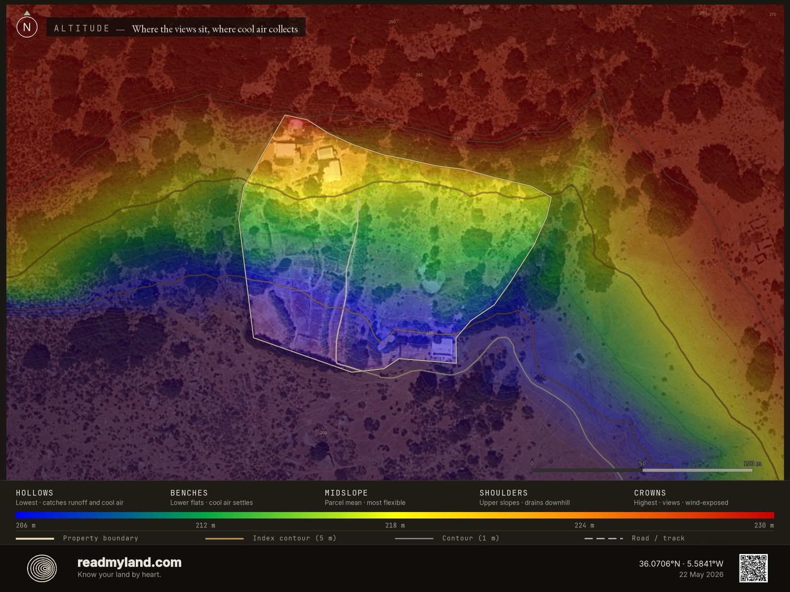
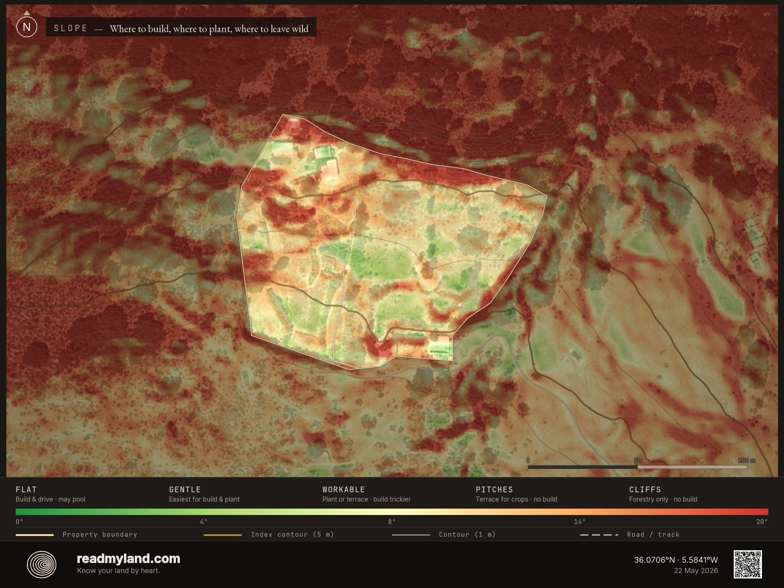
The site spans an elevation range of just 25 metres, captured at 2-metre LiDAR resolution — a gentle, rolling landscape rather than dramatic relief. The largest contiguous flat area measures 492 m² — tight but viable for a single dwelling of roughly 100–150 m² footprint with surrounding terrace, garage, or small outbuilding. Drainage across the building zones is good, reducing the risk of foundation moisture. Access is genuinely easy: a maximum approach grade of 4% means standard vehicles, delivery trucks, and construction machinery can reach the site year-round without specialised equipment. Larger structures such as barns or workshops would require terracing or splitting across multiple smaller pads.
“The trade-offs are real and surveyable. Nothing about this parcel is hidden.”
Water
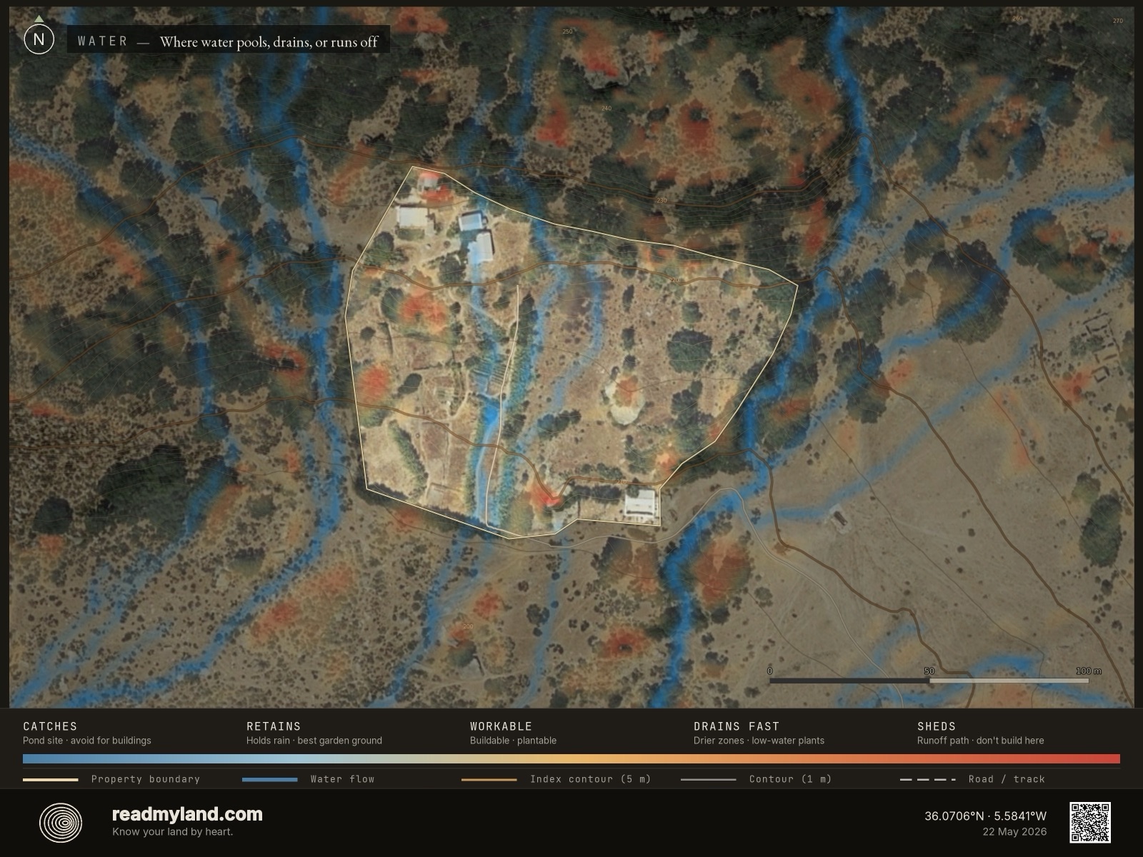
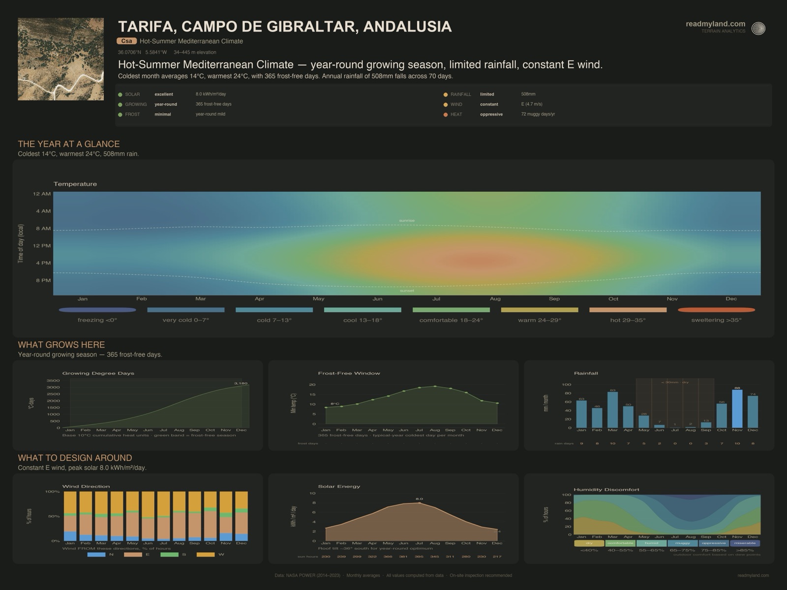
Annual rainfall of 508 mm sits at the lower edge of what rain-fed Mediterranean agriculture can sustain — workable for olives, vines, almonds, and drought-adapted crops, but insufficient for thirsty horticulture without supplementary irrigation. The seasonality is sharply pronounced: November is the wettest month at 88 mm, while July receives just 0.6 mm and August only 1.6 mm. Five months fall below 30 mm, creating a long, severe dry season from May through September. Critically, the terrain shows zero viable natural pond or dam sites — the gentle relief offers no concentrated catchment basin. Plan for engineered storage: rainwater harvesting from roofs into cisterns, or an excavated tank, typically €3,000–€15,000 depending on capacity.
Sun & Growing
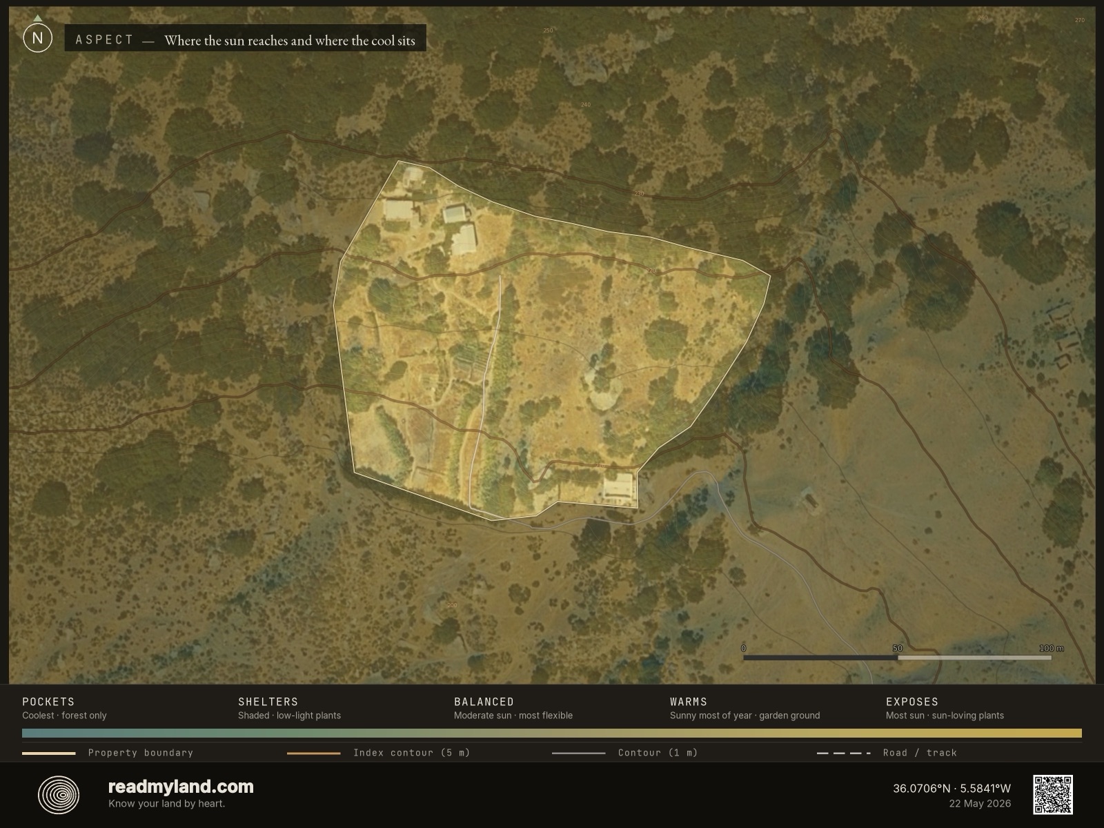
Solar exposure here is exceptional. 99% of the usable area faces south or southwest, capturing maximum incoming radiation across the day, with minimal terrain shading from neighbouring slopes. The solar resource averages 5.1 kWh/m²/day — well above the 4.0 threshold most rooftop or ground-mount PV systems target. For cultivation, 57% of the parcel — roughly 0.9 hectares with slope under 12° — is workable for crops, gardens, or orchards. With 365 frost-free days and 3,180 growing degree days, the climate supports an unusually broad palette: citrus, olives, figs, almonds, stone fruit, table grapes, and most Mediterranean vegetables can ripen here.
Climate Context
The thermal regime is unmistakably warm-Mediterranean. The coldest month averages 13.8°C in January, climbing steadily to 24.0°C in August, with September and October still holding above 20°C. Winters are mild — frost-sensitive plants such as citrus and olives can remain in the ground year-round without protection. The dry season is the dominant climate constraint: four-to-five consecutive months below 30 mm impose real drought stress on unirrigated systems. With 3,180 growing degree days, the site has thermal capacity to ripen long-season crops including wine grapes, citrus varieties, and even some heat-loving cultivars that struggle in cooler Mediterranean zones.
Risk Assessment
Fire. The EU JRC fire-perimeter archive records one fire within the 5-km query area in the 5-year window — measurable wildfire history for this part of southern Spain. Structural conditions are also present: five consecutive dry months, 24°C summer peaks, 99% south-facing aspect, and moderate fire-season wind. The combination puts this site in the Strategy-led band of the Mediterranean reference scale (score 40/100, not the higher Excellent/Strong bands). Design implications: budget €500–€2,000/ha for annual defensible-space brush clearance, site flammable structures (woodshed, hay storage) away from the main dwelling, and favour fire-resistant species (olive, fig, almond) over flammable ornamentals like Cupressus monocultures or eucalyptus.
Flood. Low vulnerability. The 25 m elevation range drains well, the dry-month dominance limits saturation events, and the parcel shows no concentrated drainage convergence points that would create standing-water risk. The 88 mm wettest-month total is concentrated but not extreme. Formal flood-zone mapping is not yet integrated in this dossier — check the national hazard map before final siting near any concave drainage lines spotted on site.
Key Opportunities & Risks
Exceptional solar profile (99% south-facing, 5.1 kWh/m²/day) makes this an ideal site for combined PV generation and warm-season cultivation. Zero natural pond sites means budgeting €3,000–€15,000 for an excavated tank or rainwater harvesting as a foundational investment, not an upgrade. Summer drought risk demands storage sized for at least 90–120 days of irrigation autonomy. The 492 m² flat pad limits building footprint to a modest single-storey dwelling — verify with local planning before assuming larger structures are feasible. This analysis is based on satellite and elevation data. It does not assess soil conditions, legal constraints, or factors requiring a site visit. On-site inspection is recommended before purchase or major development.
The layers compute the data; the maps make it readable. Every claim above traces to one of these. Read the note, then the map illustrating it.
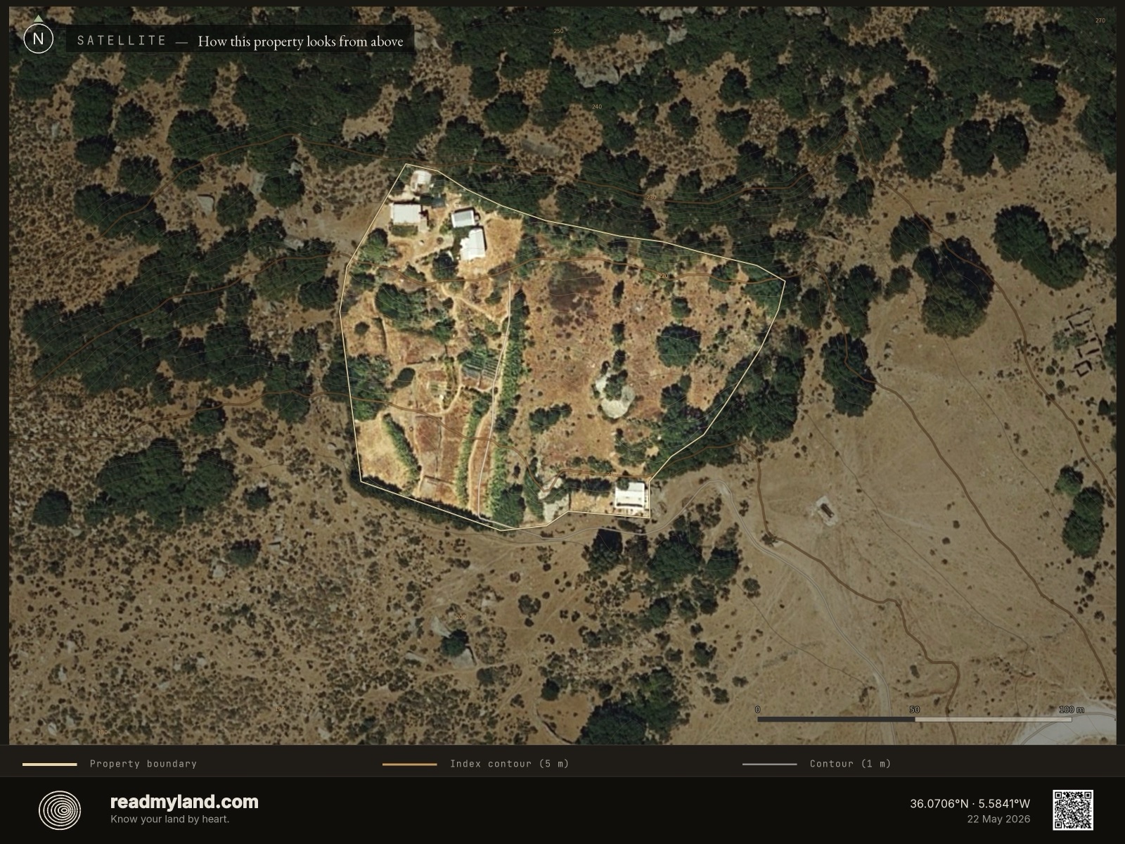
The land as it actually is
A real aerial photograph of the parcel — vegetation, bare ground, structures, and tracks exactly as they look from above. An honest first impression of the current state, and the base layer everything else is read against.
Where water collects, where it drains
Blue is where water naturally gathers; yellow and brown drain quickly. On this parcel the building zones are well-drained with no concave collection lines — good for foundations, but it also means there's nowhere for a gravity-fed pond to form.
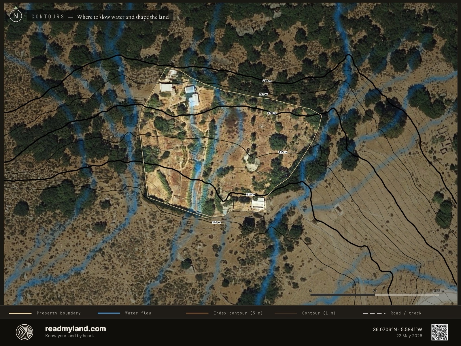
The shape of the ground and the path of the rain
Contour lines over the satellite image, plus natural water-flow streams in blue. With only 25 m of range the relief is gentle; the streams show where the concentrated winter storms run off — quickly, and clear of the building pad.
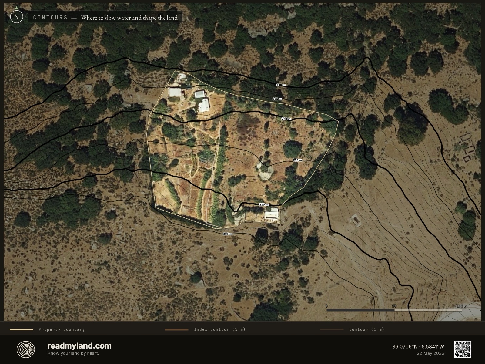
Terrain shape on its own
The same contour lines without the water-flow streams — a clean read of a gently rolling Mediterranean parcel. Just 25 m of relief end to end: rolling, open ground rather than dramatic terrain.
High ground and low pockets
Elevation as a colour gradient from low (blue) to high (red). The narrow 25 m range means there are no real frost pockets or steep drops — the parcel reads as an even, gently-tilted shelf.
How steep, and how buildable
Steepness across the parcel. Most of it sits gentle enough to cultivate — but the flat building ground is limited, which is why the largest pad covers only 492 m² even at a 4% approach grade.
Which way the land faces
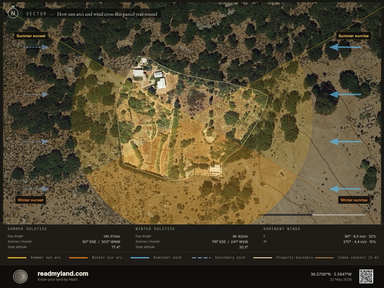
The orientation of each slope — the driver of sunlight and warmth. About 99% of the usable area faces south or southwest, the favourable aspect at this latitude. Place gardens and orchard across the south-facing ground; reserve a strip for PV.
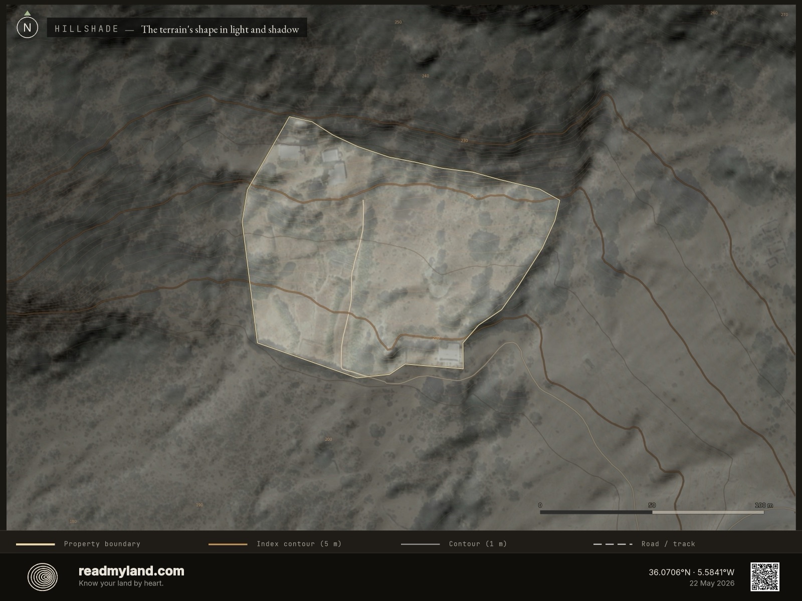
The landform, lit from a low sun
A shaded-relief render of the bare terrain — the land as if lit by a low sun, making the gentle rolls of this Mediterranean parcel legible before you've walked it.
Sun, wind, and shelter in one view
Sun paths, prevailing winds, and terrain shading combined. It shows where the strong Mediterranean sun tracks across this overwhelmingly south-facing parcel, and where fire-season wind hits hardest — so you can site the home and its windbreak deliberately.
The numbers that decide what grows
Rainfall, temperature range, frost-free days, growing degree days, and wind in one place. The 508 mm annual rainfall and five-month dry run tell you more about how to design this parcel than anything else here.
What the land can tell you.
This analysis is based on 2 m LiDAR elevation, satellite imagery, and a decade of climate reanalysis. It does not replace parcel-level soil testing, legal due diligence, or factors requiring a site visit — including planning context and water-extraction rights. Formal flood-zone mapping is not yet integrated in this dossier. On-site inspection is recommended before purchase or major development. Published as a worked example of our founder's own Mediterranean homestead, with consent.
Now read your own land.
Draw any rural parcel and get the same five scores, the same maps, and a written verdict — free preview, no account.
Trace your parcel · Free preview →