What does a coastal parcel
near Tarifa say?
We read this Andalusian coastal parcel from 2 m LiDAR elevation, satellite imagery, and a decade of climate data — the same way we'd read any land. No site visit. It's published as an anonymised worked example of a Mediterranean parcel: sun-drenched and easy to build on, but dry and fire-exposed.
This property presents a striking contrast: exceptional building terrain and excellent solar conditions paired with serious water and external-risk constraints. It is nearly flat, sun-drenched, and frost-free year-round — but rainfall is concentrated in a few wet months, summer is bone-dry, and the surrounding landscape carries a documented fire history. The parcel rewards thoughtful design.
This property presents a striking contrast: exceptional building terrain and excellent solar conditions paired with serious water and external-risk constraints. The site is nearly flat, sun-drenched, and frost-free year-round, but rainfall is concentrated in a few wet months, summer is bone-dry, and the surrounding landscape carries a documented fire history. The parcel rewards thoughtful design — strong on solar and buildability, demanding on water and fire planning.
Terrain & Building
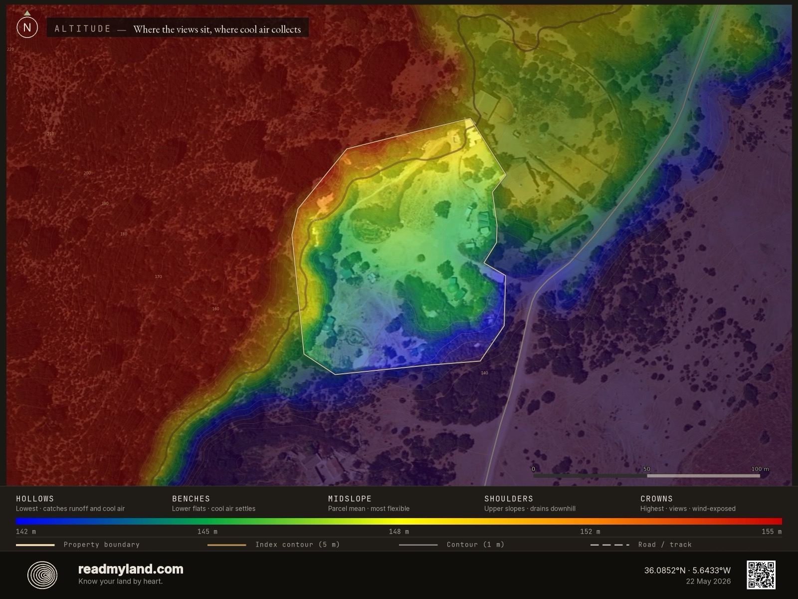
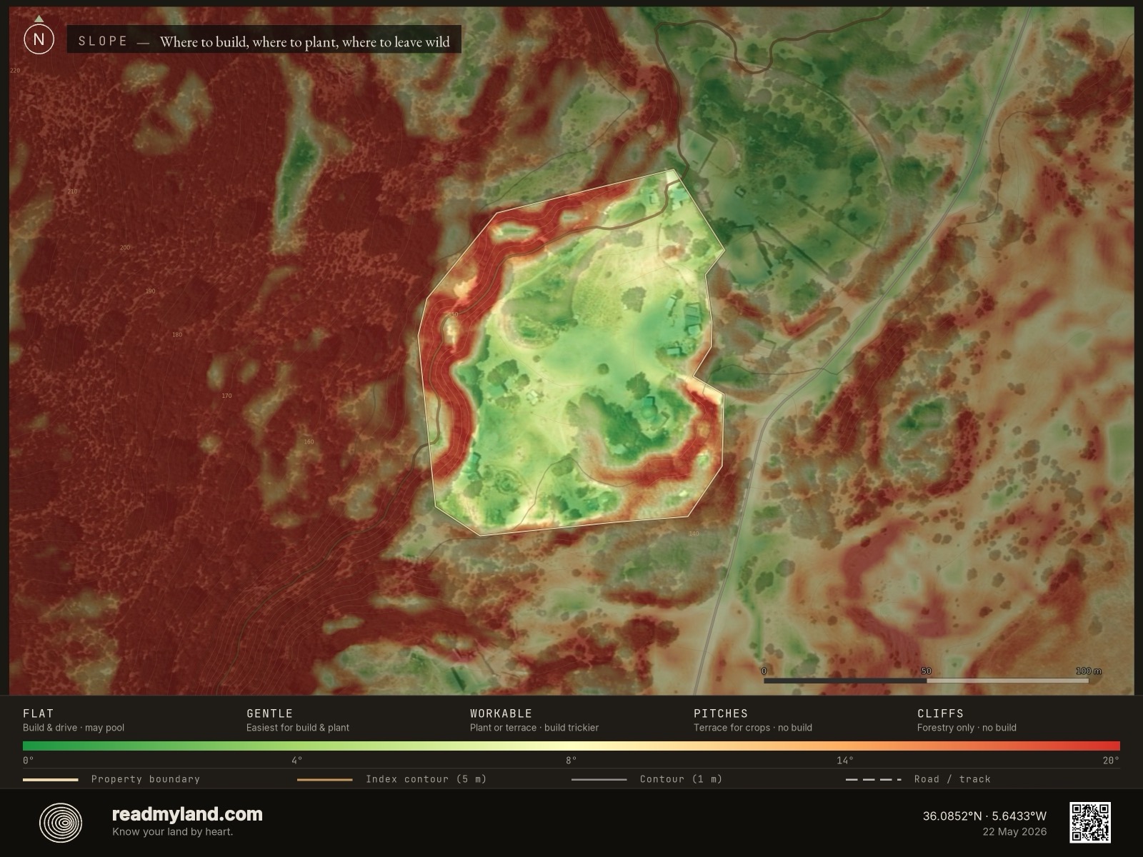
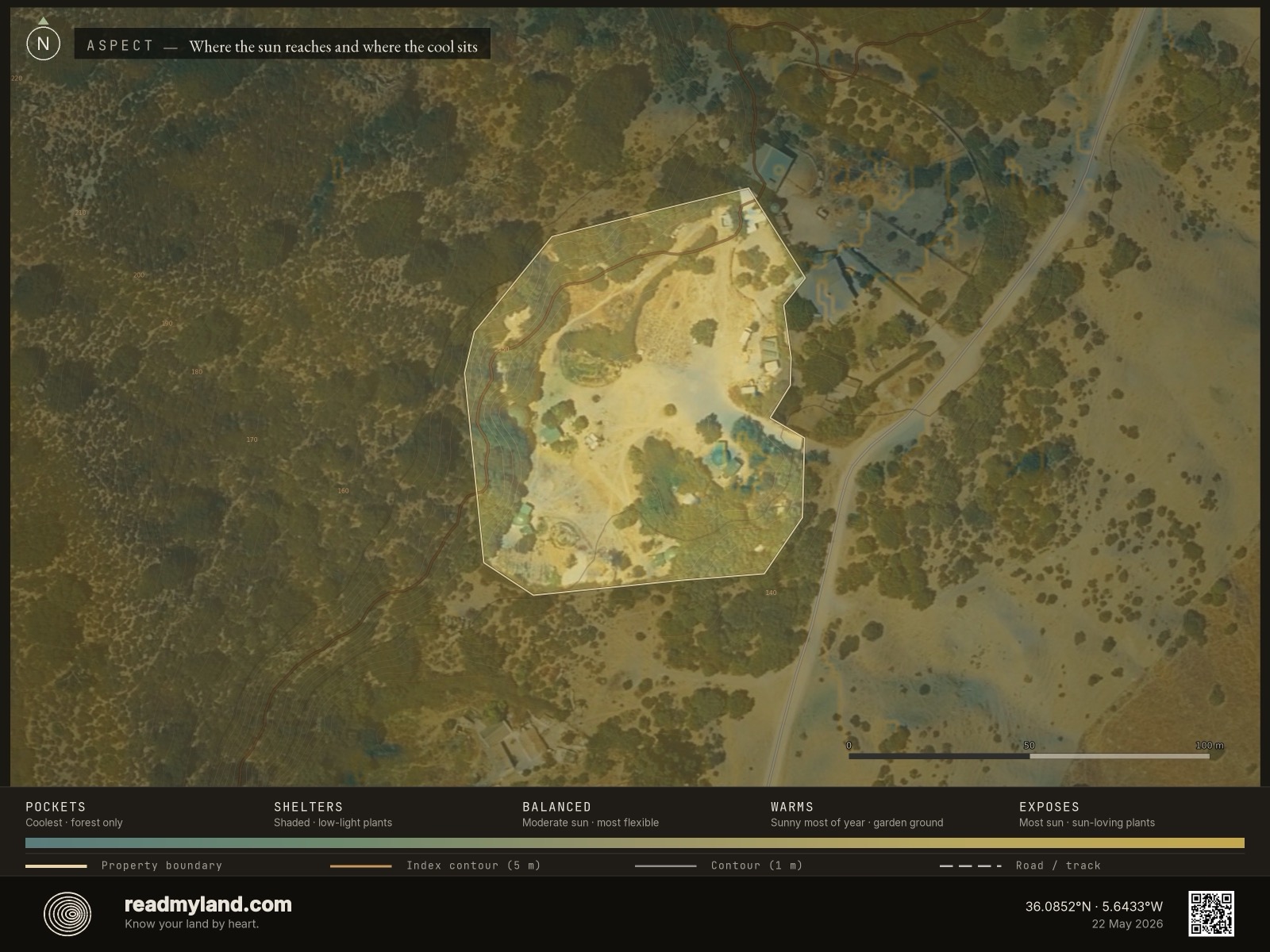
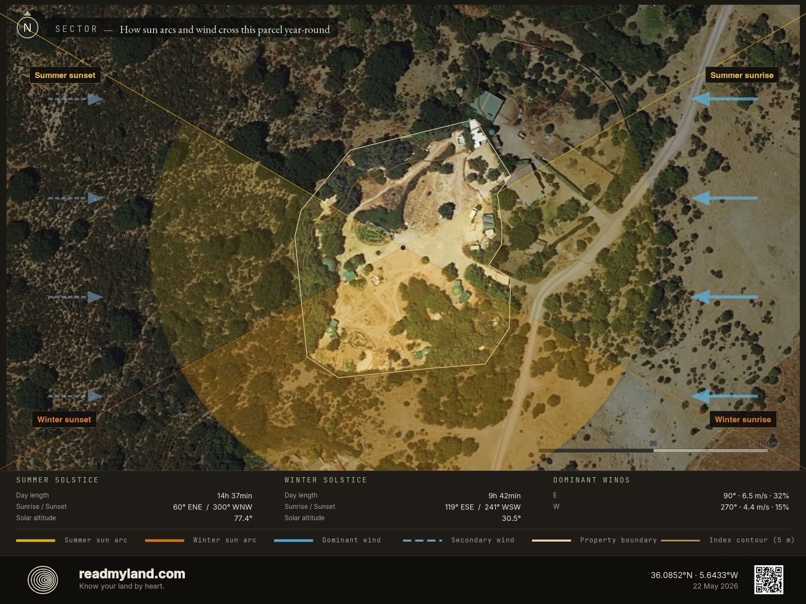
Elevation varies by just 14 metres across the parcel, with a maximum approach grade of 3% — gentle enough for standard vehicles year-round, no 4WD or engineered driveway required. The largest contiguous flat area measures 5,356 m², comfortably supporting a 200–300 m² single-storey home with terrace, parking, outbuildings, and generous garden. Drainage on the building pad is well-developed, with no concave water-collection lines crossing the buildable zone. Because the parcel sits on an east-dominant wind corridor (annual mean 4.7 m/s, February peaks of 5.7 m/s, top-quartile gusts to 7.7), orient the long axis perpendicular to the eastern boundary and design sheltered courtyards on the lee side.
“Easy to build, easy to grow on — but you design this parcel around its water and its fire, not its views.”
Water
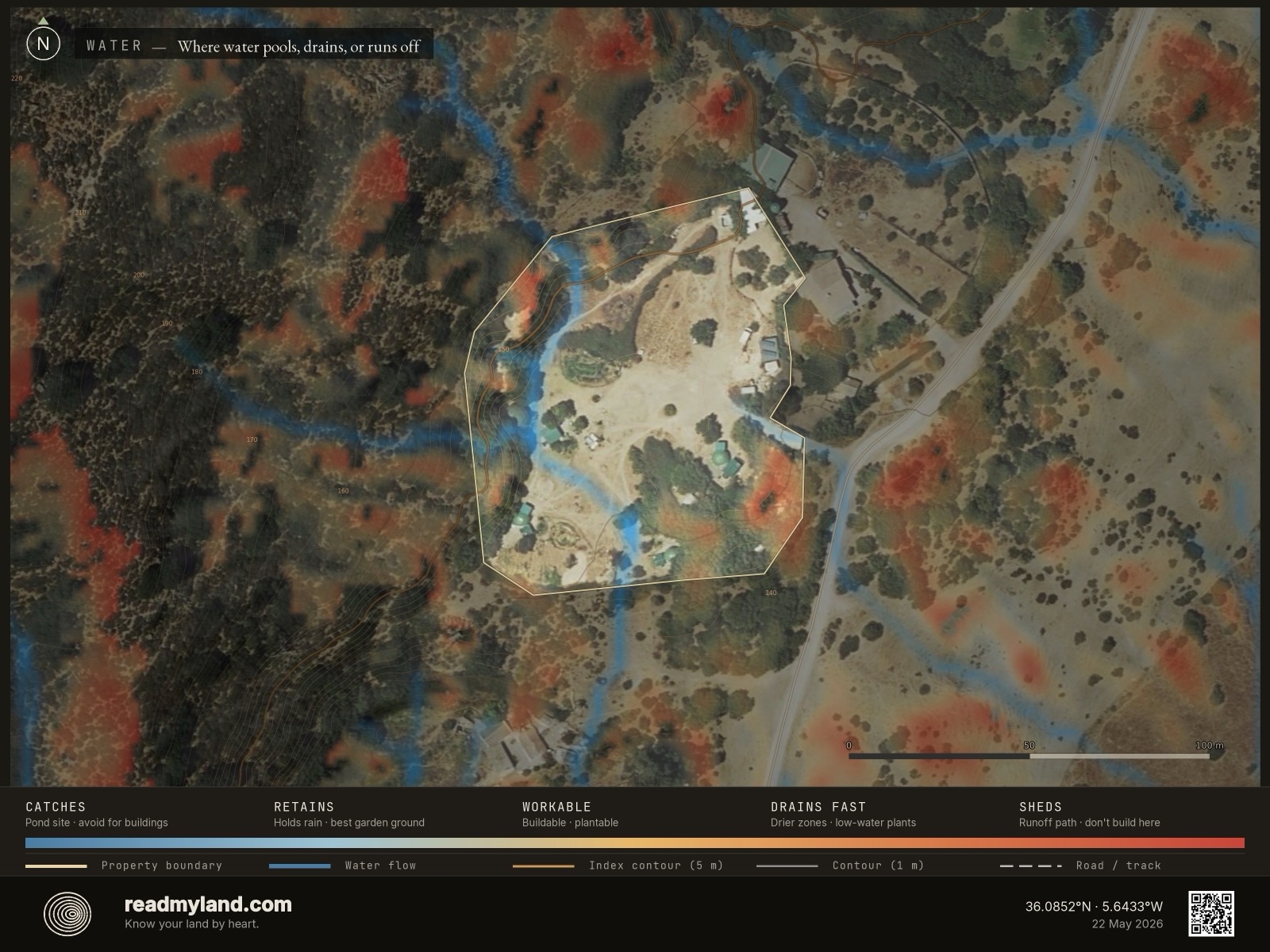
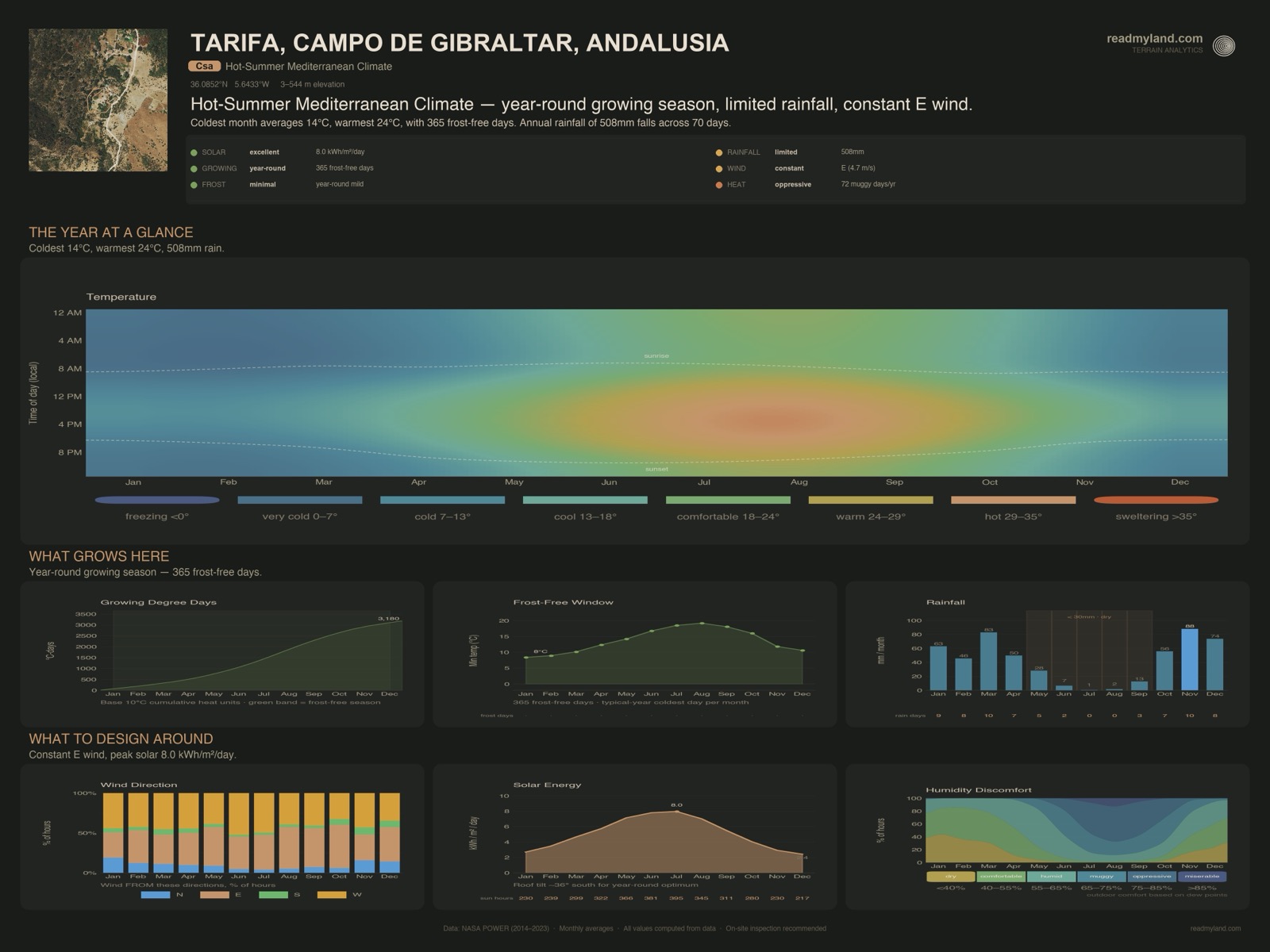
At 508 mm annual rainfall, this site sits at the lower edge of what rain-fed Mediterranean agriculture tolerates — workable with storage, marginal without. The wet season is sharply defined: November (88 mm) and March (83 mm) bracket the winter window, while June through August deliver a combined 8.8 mm and July is effectively rainless. The terrain identified zero viable pond or dam sites — drainage geometry doesn't converge anywhere — so water security depends entirely on built infrastructure: an excavated tank or rainwater harvesting off the roof (€3,000–€15,000). A 50–100 m³ cistern is a sensible starting target.
Sun & Growing
South and southwest aspects cover 67.2% of the usable area, and the average solar resource of 5.1 kWh/m²/day is genuinely productive — sufficient for both PV and intensive cultivation. With 0.7 ha cultivable, 365 frost-free days, and 3,180 growing degree days, the climate supports citrus, olives, almonds, figs, pomegranates, vines, and a long warm-season vegetable rotation. The Cambisol-Luvisol-Leptosol mix is a typical Andalusian hill-soil signature: moderate fertility with clay-rich subsoils good for tree crops, but shallow, rocky Leptosol pockets where root depth is limited — soil pits before planting orchard blocks are worth the half-day.
Climate Context
The temperature arc is gentle and warm: January averages 13.8°C and August peaks at 24.0°C, with frost effectively absent. This is a true Mediterranean climate — mild wet winters, hot dry summers — and the 3,180 growing degree days place it in subtropical-crop territory. Sunshine totals 3,615 hours/year, with even mid-winter delivering seven daily sun-hours. Rain falls across only 70 days a year, so the 508 mm arrives in concentrated bursts — design for short, intense storm events. The defining constraint is a five-month dry run (May–September); humidity averages 78%, coastal-influenced rather than continental.
Risk Assessment
Fire risk is genuinely elevated. The EU JRC fire-perimeter archive records two perimeters within the ~99 km² query window — a 591-ha burn in 2025 and a 193-ha burn in 2024 — an annual burn rate of 1.58%, at the top of the Mediterranean reference scale (>1.5% is very high). Combined with five dry months, 67% sun-facing aspect, and a 4.4 m/s fire-season wind, this parcel needs serious defensible-space planning: 30 m brush clearance (€500–€2,000/ha), redundant water storage with fire-fighting fittings, and fire-resilient species (avoid eucalyptus and dense pine near buildings). Flood risk is low — the 14 m elevation range and 3% grade drain efficiently, and no convergence points cross the buildable zone, so winter runoff moves quickly off-site.
Key Opportunities & Risks
An exceptional flat building pad (5,356 m² at 3% grade) means minimal site-prep and supports a substantial single-storey home. Against that: zero natural pond sites combined with five dry months make a cistern the critical first decision (€3,000–€15,000); an elevated fire history (1.58%/year) carries real defensible-space and insurance implications; and a dominant east wind calls for an eastern-boundary windbreak (€900–€4,000) before tender plantings. Aggregate flagged site-prep runs €3,900–€19,000. This analysis is based on satellite, elevation, and regional soil data. It does not assess legal constraints, planning permission, or factors requiring a site visit. On-site inspection is recommended before purchase or major development.
The layers compute the data; the maps make it readable. Every claim above traces to one of these. Read the note, then the map illustrating it.
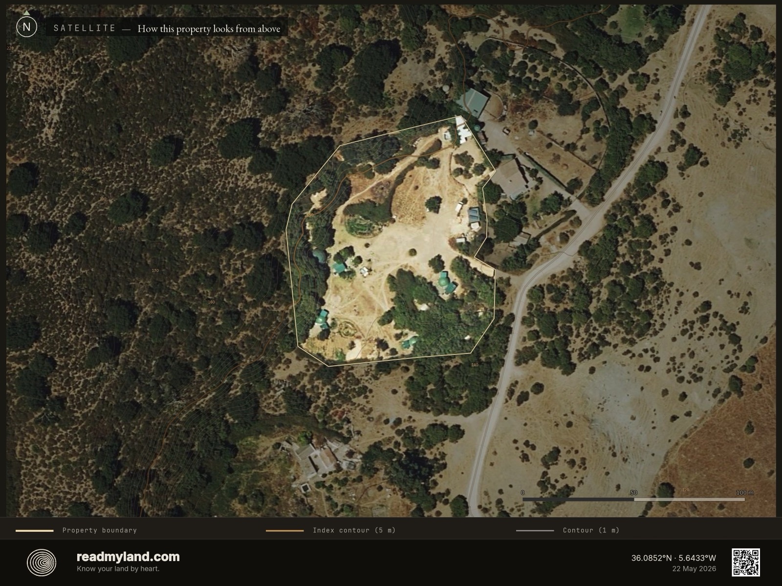
The land as it actually is
A real aerial photograph of the parcel — vegetation, bare ground, structures, and tracks exactly as they look from above. An honest first impression of the current state, and the base layer everything else is read against.
Where water collects, where it drains
Blue is where water naturally gathers; yellow and brown drain quickly. On this parcel the buildable zone is well-drained with no concave collection lines — good for foundations, but it also means there's nowhere for a gravity-fed pond to form.
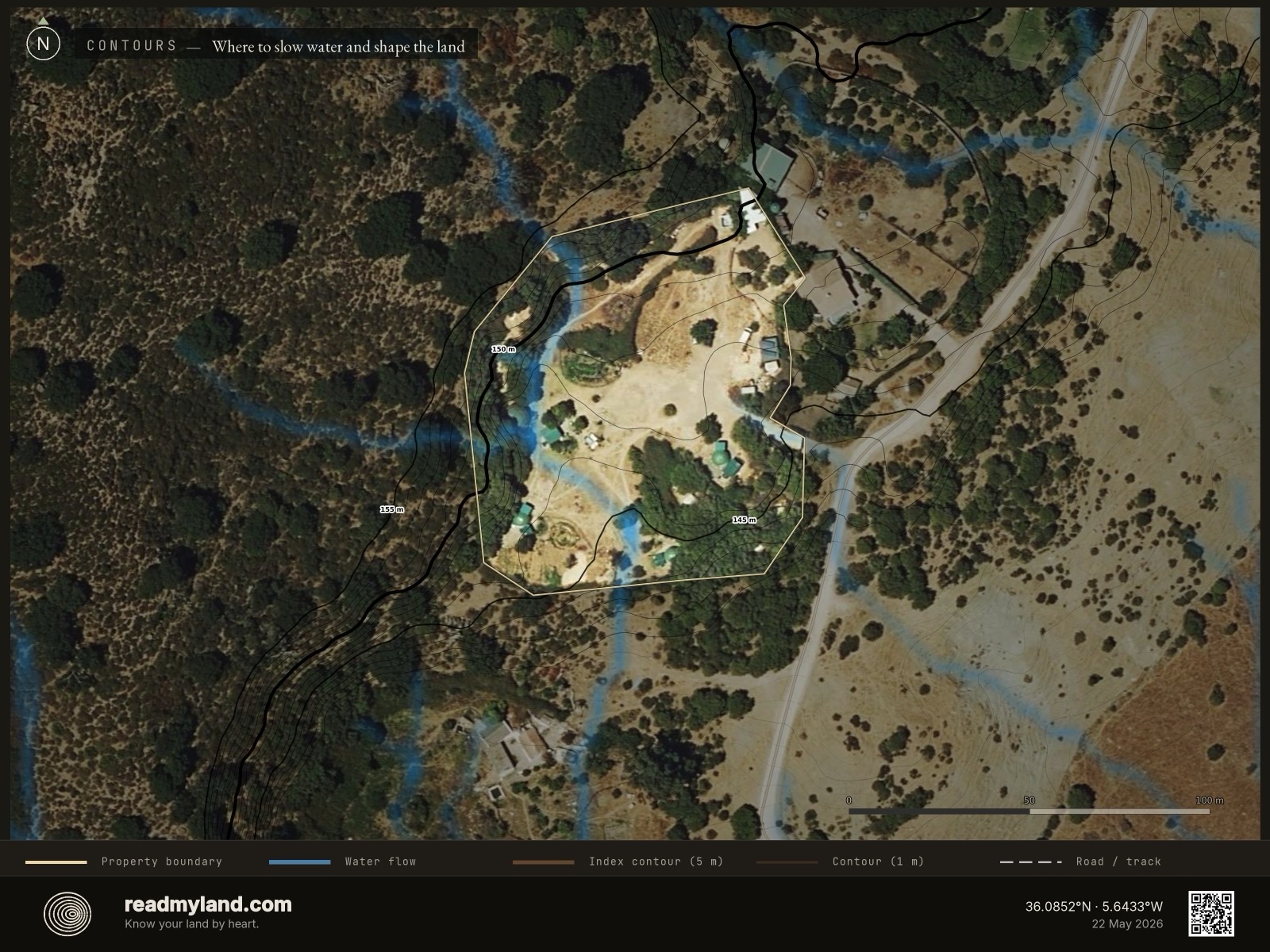
The shape of the ground and the path of the rain
Contour lines over the satellite image, plus natural water-flow streams in blue. With only 14 m of range the contours sit wide; the streams show where the concentrated winter storms run off — quickly, and clear of the building pad.
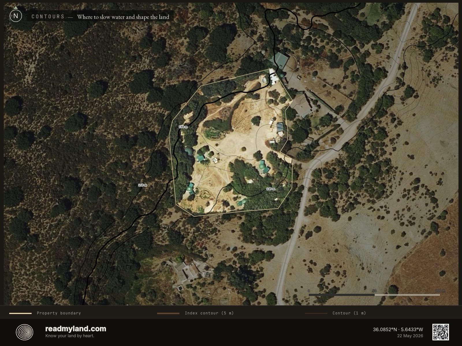
Terrain shape on its own
The same contour lines without the water-flow streams — a clean read of a near-level coastal parcel. Just 14 m of relief end to end: gentle, open ground rather than dramatic terrain.
High ground and low pockets
Elevation as a colour gradient from low (blue) to high (red). The narrow 14 m range means there are no real frost pockets or steep drops — the parcel reads as an even, gently-tilted shelf.
How steep, and how buildable
Steepness across the parcel. Almost all of it sits gentle enough to build and cultivate — which is why buildability reads 96 and the largest flat pad covers 5,356 m² at just 3% approach grade.
Which way the land faces
The orientation of each slope — the driver of sunlight and warmth. About 67% of the usable area faces south or southwest, the favourable aspect at this latitude. Place gardens and orchard on the south-facing ground; reserve the ridge for PV.
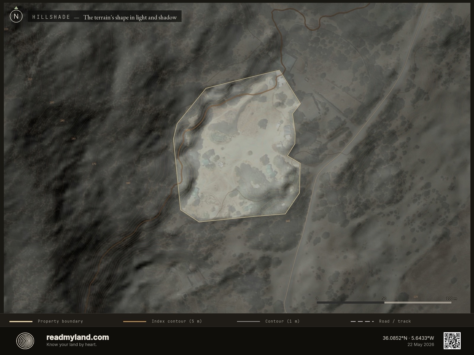
The landform, lit from a low sun
A shaded-relief render of the bare terrain — the land as if lit by a low sun, making the gentle rolls of this coastal shelf legible before you've walked it.
Sun, wind, and shelter in one view
Sun paths, prevailing winds, and terrain shading combined. It shows where the strong Mediterranean sun tracks and — crucially here — where the dominant easterly wind hits hardest, so you can site the home and its windbreak deliberately.
The numbers that decide what grows
Rainfall, temperature range, frost-free days, growing degree days, and wind in one place. The 508 mm annual rainfall and five-month dry run tell you more about how to design this parcel than anything else here.
What the land can tell you.
This analysis is based on 2 m LiDAR elevation, satellite imagery, and regional soil data. It does not replace parcel-level soil testing, legal due diligence, or factors requiring a site visit — including coastal-zone and planning context. On-site inspection is recommended before purchase or major development. Published as an anonymised worked example of a Mediterranean coastal parcel.
Now read your own land.
Draw any rural parcel and get the same five scores, the same maps, and a written verdict — free preview, no account.
Trace your parcel · Free preview →